

Day 12, Sunday, August 13 – 365 Miles
Well, I’ve seen all the wheat fields I ever want to see. But more on this later.
I left Kalispell, home of cowboys and cowgirls, by 10:30. It was a late start because I took time to wash clothes.
I drove west on Hwy 2 into the setting moon with the perfect riding temperature of 60. Soon, I was wending my way along the valley between gentle-shouldered mountains. Somewhat like CO, but very green. It reminded me of a combination of Crested Butte and Steamboat Springs, but with smaller mountains.
If you ever want to fish, northwest Montana is the place to go; I must have passed a thousand lakes and rivers.
The day was much different from the previous, where the Going-To-The-Sun road ended up being a Going-Into-The-Cold-Rain journey.
I passed Logan’s creek, Logan’s Cabins, Logan’s this and that. (In Glacier, there was a Logan Pass.) I tried to find the reason why so many places were named “Logan” but couldn’t.
I hit the most northern point of my trip, just north of Bonner’s Ferry, which is only about 20 miles from Canada. Then, south on Hwy 95.
I passed thru Sandpoint, home to a beautiful lake that is much prized for its fishing and which offers the opportunity for skiing, boating, para-sailing, sailing. It was probably one of the prettiest lakes I’ve ever seen.
I crossed I-90 (man, it’s a long way above I-10) and headed down toward Lewiston, my intended destination. Soon, with the temp now 95, I got held up for 30 min because of construction. Sitting on the damn bike in that heat is a real pain.
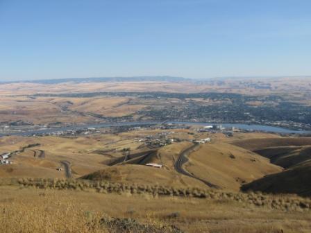
But, afterwards, I was curving through the wheat fields of northern Idaho. Let me tell you, Kansas or any other place that grows wheat has nothing on this place. Note the pictures. Almost every inch of land was cultivated, even up the sides of the steeply rolling hills; it reminded me of the pictures of China, where the land is scarce.
At one point, I realized that Idaho had it backwards; they had “crop squares” instead of “crop circles.” See the pic.
Eventually, I topped a rise and saw Lewiston below me, situated between the Snake and Clearwater Rivers. Lewis and Clark had made a stop here in 1805. Eventually, it became a port for steamboats. The Nez Perce Indians lived there, enjoying the “banana climate” that is the result of warm air funneling through the lower river valleys. (Only a fifty miles north, a Honda rider I met complained about the -10 winters.)
Got a great hotel, had dinner, met some bike riders, got some advice and am now planning the rest of my trip.
I have changed my plans and will not to go to Seattle. There just isn’t enough time. Instead, I’ll run west on 12, parallel the Columbia River for a while, then head south on 97. 97 will take me through Bend, Oregon, by Crater Lake, and along the Cascades.
Taking this route will eventually lead me to 395 that will take me pretty much straight to LA. I’ll do the Redwood Forest and the Pacific Coast ride another time…maybe when (if, ha!) I ever have another girlfriend.
So, I should be back to Shreveport, via Boulder, CO by August 25-26-27.
By the way, Lewiston is in the Pacific Time Zone and is farther west than LA. How about that!


3 comments:
Land of the Open Sky is what the native Americans called it. Isn't this also the landscape of Costner's "Dances with Wolves?" Yep, can see crop squares; explain, please.
Buffalo steaks might be available at some restaurant on your route.
in fun
Beats me with the squares...must have something to do with harvesting.
About them crop squares..... Crop circles are of course created by the hands-on-a-clock type of rotation of the farmers' sprinkler irrigation system (out here in the dry west). My hunch on the crop squares is that where you are traveling, they get enough moisture that either they don't have to water, or use channel like irrigation and can thusly farm the whole field.
I knew that this was a hot topic and was probably making numerous people loose sleep, so I jumped right on it with all of my "Blonde, Midwestern Smarts"!!
......Oh, and then we get into crop rotation. That's where you see wide field of golden wheat alternating with the brown dirt of the fallow fields. They do that to give the fields a chance to "rest" every other year.
More than you ever hoped to know about farm fields....thank you very much.... (Mt.Lay)
Post a Comment