Thursday, June 18, 2009

Where John Wayne Rode...Monument Valley


June 18, 2009

This morning I walked down the street to get coffee while Jes slept in and stumbled into a fantastic café. I booted up my little netbook and sipped from a cup of tasteful and aromatic coffee while sitting amidst a desert garden, listening to the miniature waterfall in a little Japanese pond that three big multicolored goldfish called home.

Our plan was to drive south on Hwy 191 to Blanding, and then cut west on 95 and then south on 261. We bucked a headwind all the way south to Blanding, which is located on a kind of mesa, right at 6,100 feet. We still wore jackets and gloves, but no rain gear needed, thank god.

When we turned onto 95, I knew it was a good choice, because we saw nobody on the road that swooped through the canyons like a hawk. The road required constant shifting, but that was just fine because it was so nice. Along the way, we stopped at some Anasazi ruins. Jes and I both commented how so very exciting it was to gaze upon a place that was bustling with activity 800 years ago.


We turned south and the first thing we saw was a sign that said, “Narrow gravel road 23 miles ahead.” I’m thinking, “Huh? WTF? Two years ago I had driven this same route the other direction, and I just didn’t seem to recall anything special. Oh, well.

But, 23 miles later it all came back to me…we would be driving right down the side of a mesa bluff into the area just north of Monument Valley. Two years ago I had driven toward this wall of red stone thinking, “Where’s the road up?” I think the pictures will show exactly what it was like.


This picture was taken looking over the back...this is the rock wall we had just driven down!


Once down, we stopped in Mexican Hat, shared a burger, and saddled up again, looking forward to Monument Valley, the site of filming for many John Wayne movies.

What is amazing about the buttes of Monument Valley is that the whole valley floor used to be the same height as the top of the monuments. Wind and water subsequently worn down and carried away all the softer rock, leaving the harder stone behind, standing in tall spires.


A traffic accident put us on a detour in Kayenta, a town in the Navajo Nation, and we were stop and go…mostly stop. At one point, when I let the clutch out, a hammer of wind hit us…so hard that it ACTUALLY PUSHED US BACKWARDS ON THE HARLEY. I swear to god we rolled backwards a few feet while I fought for balance. I didn’t want to gas it and go because I wasn’t sure if I could stay upright, so I just locked the front brake and braced my feet on the ground. Then, suddenly as it came, it was gone. I said to Jes, “Shit! That was as strong or stronger than the wind burst we hit yesterday.” (The day before, after the final gas stop while on the way to Moab, we had just gotten back on I-40 when we were hit by a gust of wind that felt solid as a fist.) Later, Jes told me, “Yeah, I was filming and saw the dust storm coming.” I’m like, What? Why the F didn’t you tell me!”

Later, when we reviewed her video recording, it was clear what had happened: a very big dust devil had blown our way and passed over us. Fortunately, we were stopped when it hit, because a Harley is fine when moving right along, fine when stopped, but there is a moment of transition when beginning to roll when balance is a little iffy.

At Kayenta, after we checked in, a group of Harley riders pulled into the Holiday Inn. Turns out they were Italians who owned Harleys back in Italy and who had rented them in Las Vegas and were doing a tour. They even had Italian Harley leather jackets on! One of them said,"Everything is bigger here...even the Cokes." And, yes, ALL of them, men and women, young and middle-aged, were NOT carrying pounds and pounds of extra weight. Go figure.

As usual, supper, download pictures, discuss tomorrow…which, in this case, will our last day on the Harley.

Mike Sledge

Moab, Biblical Burial Site of Moses


June 17, 2009

Once again, I got up and got coffee and checked my computer for email and stock market trends. Then, of course, take coffee to Jes to jump start her. Our plan was to make it an easy 180-190 miles to Moab. Moab is named after the biblical burial land of Moses, who, as you know, did not make it to the Promised Land.

We left Richfield and motored east on I-70. I knew the San Rafael Swell was ahead of us and was looking forward to it. (I had heard much about this geologic formation while living in Boulder but hadn’t had the chance to view it.) The wind/air temp was just about perfect, but we pulled over to don rain gear just in case.


We did a lot of climbing going up the west side of the swell, and reached a great viewing point. The Native Americans were there with large spreads of jewelry. (I wonder if that stuff is really made in Thailand or somewhere.)

Then, we rode the down into the San Rafael Desert. Going up, over, and down the swell presented us with fantabulous sights, and these pictures really don’t do justice to the geography. The scale of mountains, plains, mesas, and other western geography dwarfs what you see in Arkansas, the Hill Country of Texas, and even the Appalachians. You really feel as though you are just a mote when you ride down a cut made through huge stone walls and find yourself staring out at mountains that are 30-40-50 miles in the distance across the high desert.


We got gas just before turning south on Hwy 191 to Moab. Moab, UT, is the setting for a novella I’ve finished (are we ever finished?), and driving back to the town was like going back to see an old friend.

After grabbing a hotel, we went to get a snack, and then rode around some. We ended up taking the road that leads to Slickrock Trail (a famous mountain bike jaunt) but pushed on to where the road turned to gravel and then kept going another ten miles or so. When we stopped to take a break, stretch our legs, and snap some pics, Jes called to me from behind where I was standing. “Hey, Papa, do you think we need to worry about that?”

I turned and saw some dark clouds a few miles away approaching…and it was obvious that they were dumping rain. We were way high above the town and miles away, so I was most concerned about lightning. Fortunately, we missed most of the rain.

After taking a cat nap, we decided to do some more looking around and find somewhere to eat. I had a place in mind, but didn’t tell her about it until we started up a horribly-maintained asphalt road toward a very oddly shaped structure at the top.

“That’s a great dinner place,” I said. “Been there before and it was delicious.”

It proved to be an equally enjoyable experience this time, too, although the rain drove us off our outdoor dinner patio and inside for shelter.


We did our usual TV thing, throwing the remote back and forth, telling the other to try and find a good channel. Terrible TV all week, but that was really just as well.

Lights out at 11 or so.

Mike Sledge

Wednesday, June 17, 2009

Heaven Is On Earth...Esp. When It Rains In The Mountains


Tues, June 16, 2009


I woke up in St. George and grabbed my neat little Asus Eee PC (a 10.7 in screen, 160 gig hard drive, 7-hr battery life netbook) and headed for breakfast…coffee in particular. The second thing I do is to check the weather. Hmmm…well, today might be a “wet day.” And it was!

By the time Jes got up (“Papa, I swear it’s like a meat locker in here!” is her morning mantra) and we got going it, it was clear that the sky would not be. Rain garments went on top of the items in the saddlebags.

We ran north on Hwy 18 out of St. George, planning on stopping first at the Mountain Meadows Massacre. It was, as before, a gorgeous drive, and intermittent light rain sprinkled us on the road.

Thirty miles later we pulled into the memorial sites, one of which is an overlook that has a memorial marking the names of those killed and several markers that provide the history of the tragedy. To make a long story short, an emigrant wagon train from Arkansas was ambushed by a group of Native Americans and Mormons from a local settlement. For reasons still not exactly clear, a Mormon militia joined in the attack. (This was during a time of the Utah War, when the US decided to assert its authority over the region and the Mormons resisted.)

After a day or so of continuous assault, a few people of the wagon train were killed and a “truce” was arranged in which the emigrants gave up their arms in exchange for a promise of safe escort out of the region. About a mile from the initial camp where the attacks began, the now-unarmed emigrants were slaughtered, save for all children under the age of seven (it was thought that they would not remember the incident).

Eventually, Brigham Young threw his son (one of them…nice to have some spares, no?) under the bus and who was eventually executed for this crime. Over time, the memorials were updated and improved.

The second memorial site was down in the meadows below the overlook and it contained the graves and stone cairn commemorating the burial site. It was really a beautiful place, one worth taking a side trip off the regular travel routes.


We decided to put on our rain pants in addition to our jackets we had already donned. The bad thing about riding a motorcycle when it’s wet is that if you wait till it’s raining to stop and put on rain gear, you’re doing so when the sky is dumping on you and it’s really too late.

Of course, along the way there were the usual stops for pictures. I love these that Jes took.


We made it to Cedar City on I-15 and took a look at the map. What the heck, we decided. We’d take the canyon road, Hwy 14, back to Hwy 89 (the road we had been on leaving Flagstaff.) and then head north. We were thinking that it would be too wet to ride the interstate up to Salt Lake City. On this account, we were truly correct, but we had hell still ahead of us.

As we rode up Hwy 14 heading east, I told Jes, “Well, it’s a canyon road…it might stay down low….unless, of course, the town was the bottom where the river ran out and we would be climbing to the mountains.” My words proved to be prophetic.

We climbed and we climbed. I pulled over and put my heavier pair of gloves on. We climbed. It rained on us…thank god not a downpour but a steady drizzle. Not much traffic. NO MOTORCYCLES coming the other way…definitely NOT a good sign.

Up, up, around and around…really pretty but really cold. By the time we pulled over at the junction between 143 and 14, it was about 40 something. I looked at the map and decided to take 143 where it led to 148 and then take the east turn down the mountains. This would put us up in the mountains a little longer, but drop us back onto 89 considerably further up the road. This decision was a mixed blessing, for we had a very rare view at one overlook, but we spent more time in the rain and cold.

And we continued up. Then, we saw snow alongside the road, which brought laughs. By now, we’re at 35 degrees. We really aren’t cold except for our hands, and it’s kind of important for a cycle rider to be able to work the hand controls, you know.

We stop at a pull out in which there was a viewing area overlooking a part of the mountain that seemed to have just sheared away, much like a tooth will break from the crown down to the root. (I’ve got to look that up on the net later.)


We get back on and continue climbing. We saw one sign that gave the altitude at just below 10,000 feet, but the road climbed for quite some time after that. I had to stop a couple of time just to take my gloves off and blow on my hands.

Once we crossed the summit and started down, the needle on the thermometer mounted on the bike started climbing….we were descending into heaven, I’ll say.

In town, we stopped for an afternoon snack and to get hot chocolate. I checked the map and we talked. It was clear that monsoon season in Utah was going to dump rain on the west side of the mountains we had just crossed, so we decided to go east, stay the night on I-70, then head to Moab the next day.

We saddled back up and motored the next 70+ miles north on 89. The road was nice, we had a wind in our back so I set that little puppy on 70 and let ‘er thunder down the road. A Harley big twin with the right pipes creates such a wonderful sound…not too loud yet you hear those big pistons just pounding away, their stale breath coming out through the exhausts in a steady, muted roar. It’s easy to get into a Zen state where your thoughts wander as the vista unfolds.

We turned east on I-70, got to Richfield and decided to make it an early day.

Great hotel, wonderful pool (it feels so good to get some exercise after a day on the bike...and it is NOT a good thing that I float better than I used to), dinner, movie, talk, bed.

I love my daughter!!!!

Mike Sledge

Tuesday, June 16, 2009

Flagstaff to St. George via Colorado City

Monday, June 15.

Of course I got up first. Thank GOD for coffee. We drove to the storage rental place and unloaded the Harley, suited up, and took off.

Jes is a wonderful riding companion. She doesn’t complain, keeps her balance, and hangs tough when the ride gets difficult (more on this later).

We rode up Hwy 89 out of Flagstaff, took the alternate 89 turnoff.


This took us to the Arizona Strip. The Arizona Strip is the part of Arizona above the Grand Canyon and below the Utah border. There’s a whole lot of nothing there.


The weather at first was cool, sixty something, but gradually warmed up to the eighties and we began unzipping and removing extra clothing.

Our stop for the night was planned to be St. George, UT, but we wanted to go through Colorado City, first, because it is home to the FLDS church. The Fundamentalist Church of Latter Day Saints, an offshoot of the traditional Mormon Church, owns most of the land in Colorado City and the neighboring town. Driving through it gave Jes and me the willies.

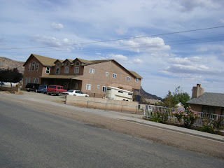
The first thing you notice is the very large homes, many of which have no final treatment, siding or brick, done to the exterior plywood walls. These homes are often situated in walled compounds…not fences as you might know them, but eight and ten foot solid walls; you can’t see in or out, and that is intentional. There are other homes, also large, that are nicely finished out. Why are the homes so big? And, why do many have as much playground equipment in the back yard as some schools do? Stay tuned for the answer.


The second thing you notice is the absence of children, or anyone else walking around, as you would normally expect at 4 o’clock on a weekday. No kids riding bikes, nothing.

This is not to say that there weren’t kids, but they were all escorted by a woman (usually young), and they were all obviously on their way to someplace. The women and girls all wore the same kind of prairie school dress…long, blue or pink, and with a white frock. Their hair—no matter what age—was also the identical coiffeur: pushed up in front, long on sides and back. The boys wore identical dark slacks and blue shirt.

Suddenly, a string of big cars came from a side street. The drivers were men and all wore the same dark suit and light-colored tie. Apparently, a meeting of some sort had let out.

No dogs, no cats, no barking, no horn honking, no sounds of laughter (I’m sure they DO laugh at the right time), no typical city-life activity whatsoever.

The very little kids would watch us with big eyes as we drove by on the Harley, and you read the excitement in their faces, but their “keepers” quickly shut them down. No one returned our wave, save one young girl who drove a 4-wheeler full of kids in their matching kits.

Now, back to the big homes: they are big because the men have more than one wife, all of whom try to have hordes of children.

Now, here’s the scary part of our experience in Colorado City: if here, in America, we can have a cult or extreme religious sect seclude itself such as the FLDS does and brainwash its members such as the FLDS does, imagine how horrifically the self-isolating groups in Afghanistan and Pakistan and elsewhere can determine the kind of life those in their power have to live.

Mike Sledge

Dinosaurs Still Eat People


I got up early on Sun, June 14, and drove toward Albuquerque where my daughter, Jes, was scheduled to arrive at noon. The wind from the south was brutal, constantly pushing my car and trailer to the shoulder and forcing the engine to get out of top gear. But, wind or not, I pulled up right about the time that she landed.

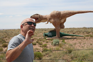
We motored toward Flagstaff, and pulled over to the side where we saw some dinosaurs in the field. Oh, wait…it was a statue thing. The little sucker tried to eat me!

Back in the car, Go West! Of course, we have to stop by Meteor Crater. That is one big hole in the ground. Jes was really surprised; she thought it was going to be something like a big splatter like from when you throw a stone in a mud river bank.


We got to Flagstaff and found a good hotel. Supper, talk, bed.

Sunday, June 14, 2009

Tucumcari, NM...You Need To Go There


Tucumcari straddles historic Highway 66, the road upon with the eponymous movie was based (Route 66 came about at a time of transition and movement of both people and ideologies; it was filmed when the interstate highway system was rapidly supplanting the two-lane road that had served as a primary migration route between the heartland of the U.S. and its upstart younger brother, the west, California in particular. To travel Hwy 66 at that time was to travel through time, forward if going west and backwards if going east.).

The town is redolent with aching knees, cataracts, big waistlines, and hair the color of Midwestern snow that has laid on the streets and sidewalks for months. I-40 bypasses it, leaving it to wither like a river cutoff…but not entirely, for the signs on the four lane speedway beckon you to divert from your fixed path and plans.

I pulled off and first encountered the usual grouping of new lay-over establishments, all of which lay apart from the town proper, like a young man who has returned home from college and who avoids his buck-toothed relatives at the family gathering. I drove on, passing by an abandoned go-kart track whose buffer tires marked the paved curves that had surrendered to encroaching dirt and grass.

The heart of Tucumcari still beats, though much less strongly than before. As I slipped back to the days of rolled-down windows, stick shifts, and unleaded gas, I imagined the crowds at the faded art-deco stores and motels, passing the wooden Indian standing nobly and stoically at the door to the general store. Gas station attendants didn’t ask to check your oil, they just did it…and threw in a windshield cleaning to boot. Kids sweated in the back of station wagons, fathers’ hair oozed brylcreme, while women’s red scarves kept bangs out of sunglassed eyes.


As is my usual wont, I rode the back streets, looking behind the redone façade of main street. It was as expected: loose dogs, doves preening and cooing, cats sauntering, and kids doing what kids do…in this case, riding four wheelers around and around in a yard that had been converted into a mini race course. The father stood on the porch with a hose, spraying them as they rode by. Glees rang out over multiple exhausts.

Elsewhere, trailers (none of which were younger than thirty or forty years) were mixed in will more permanent dwellings. All housing structures were small. (How do the accumulated memories of their inhabitants fit within such tight confines?)

But, of course, the residents aren't without their sense of humor, considering the picture below.


The wind—wondrous steady companion of my childhood days in South Texas—recalled to mind feet sticking and burning on hot tarry streets, dogs mating in the local sandlot, bike tires that constantly were flat from the unavoidable goat head thorns that also broke off in the soles of our feet, only to fester and finally come forth with a geyser of puss.

Taking advantage of the wind and standing by a state-of-the-art school (if you judge by the physical facilities), a lone windmill spins its three arms. It, perhaps, is the town’s defining landmark, a sign that Tucumcari has a future. Or, perhaps it’s the other way around…the town of stucco at the foot of the aluminum monolith reminds us that the future was born in the past.

Mike Sledge