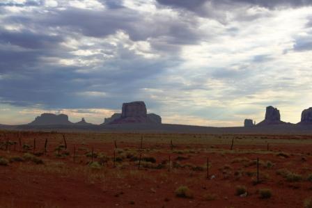
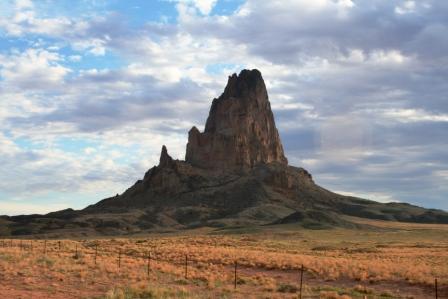
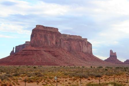
pic 1, 2, 3: buttes in Monument Valley
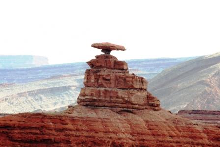
pic 4: Mexican Hat
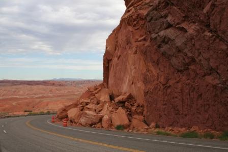
pic 5: rock calving near road...would have hated to be there when it happened
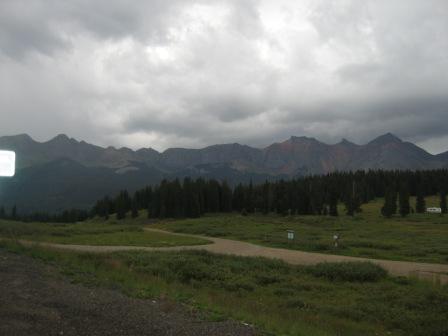
pic 6: small section of San Juan Mountains looking down on road
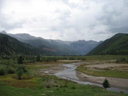
pic 7: Telluride is located up ahead in this canyon, up against the jutting sides of the San Juan Mountains.
Day 21 Tuesday August 22 - 310 miles.
MY BUTT IS SORE!
I got up early so as to see the eastern rising sun light up the buttes in Monument Valley. Alas, the sky was cloudy! And, it stayed that way all day wherever I went.
I drove north on Hwy 163 into Monument Valley. It was much more impressive than the pictures show. To really do justice, I’d have to get the light right and have a superwide lens. Here’s a good site for more pic. http://www.americansouthwest.net/utah/monument_valley/index.html
You might notice the thin red to black coating on some of the rocks. This is “desert varnish” owes its origin to microscopic organism that interact with the rock’s minerals and water, leaving the oxidized residue. Here’s a place for more info: http://www.nps.gov/cany/nature/geology/varnish.htm
(OH! While typing this I saw that there will be a new season of Nip/Tuck on FX TV. Great! What a dark show!)
I came upon a small, small town named Mexican Hat on the San Juan river and, of course, wondered where the name came from. Check out the pic and all is explained.
Before I reached Bluff, which is on a turn back to the east and south on Hwy 162, I climbed up a section that had “Road Damage” signs on the shoulder. Coming around a corner I saw why: some of the soft, sedimentary rock had “calved.” The picture shows a large chunk of rock that has sheared away from the cliff and fallen dangerously close to the roadway.
By the way, I had been playing leap frog with a car of Belgium tourists, them stopping for pic and then me doing the same. The whole eastern side of Utah, with its deserts, canyons, and mesas, is very popular to Europeans; they have forests, they have mountains, but they don’t have the red deserts and huge, eroded canyons and buttes that we do.
At Bluff, which is appropriately named, situated between the bluffs on both sides of the San Juan river, the land became dryer even the cottonwoods struggled, with many giving up the fight and their limbs and trunks becoming wasted visages of a better time.
162 ran into 160 that led to Cortez, and the road lay atop a mesa that was surrounded by the Colorado version of Monument Valley buttes, only these eroded pinnacles lacked the red color of those only 50 miles west.
At Cortez, inhabited by a large number of Native Americans, irrigation had been put to use and I once again was reminded that a little water can work miracles in dry soil.
From Cortez, I headed north on Hwy 145 that led to Telluride. I’ve always wanted to see Telluride, hearing that it was really isolated, situated at the end of a box canyon as it is.
Telluride was originally founded during the late 1800’s, as were many Colorado towns who owe their existence to mining, particularly gold and silver. And, like those towns, it almost died when silver prices were deregulated in 1893. And, like many town, it was saved by the selling of “white gold,” or, skiing.
It is nestled in a gargantuan box canyon formed by the San Juan Mountains. Unlike Aspen, Keystone, Vail, and, to a certain extent, Crested Butte, Telluride has “no way out” other than the way you came in. The town has, in the last few years, benefited from (or succumbed to…the same result is viewed differently) the real estate boom of ski-resort properties and tourism.
But to get there, I had to travel through rain coming over Lizard Pass, and I decided to have some coffee (God, it was the best ever) while waiting for the skies to clear.
After an hour, I put my rain gear back on and headed back out north on 145. The rain was not too terrible, but I had left my clear visor in LA for Logan to mail to me (I’m trying to lighten up for the final leg) and, even tucked behind the windshield, the rain drops stung like a million little bees.
I turned right on Hwy 62 and was greeted with the stupendous view of the Uncompahgre Peak to the right, heading up a platoon of fellow titans that looked down on the road.
The final run to Montrose was fast, about 80. I had been driving slowly because of the rain and the sharp turns and Harley begged to stretch his legs. We had left the San Juan Mountains and only the Uncompahgre Plateau guarded my left flank.
The motel is cheap, extremely clean, and run by the sweetest little old lady. And the internet is blazing fast. Yeah!
Tomorrow I’ll do the Black Canyons of Gunnison and head toward Carbondale, I think. I may go another way, but I want to take my time in the canyons, so Carbondale may be it. This will give me time tomorrow to work on investments and write some. And, I think I’ll read. Am currently reading a Harper’s story on the deplorable and unconscionable actions taken by the current administration with regard to the detaining and interrogation of suspected terrorists, some of whom are known by even the interrogators to pose no threat.
Low Point of the day: The clouds over Monument Valley
High Point of the day: Hanging out in the coffee shop in Telluride. It’s so nice to get back to CO where, everywhere you look, people are so fit.


1 comment:
Ah, the Western Slope. I wondered if you'd go through Cortez, my old home. Glad to know you are "home" in Colorado. I suppose tonight you are in Louisville?
Post a Comment