Here is the post from a N. Dakota blonde. Please keep in mind that it IS written by a blonde. I'm not sure if she had already had a glass of wine, or microbrew, or two before writing this, but it is funny. Mike Sledge
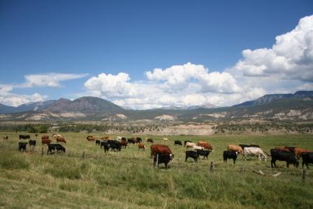
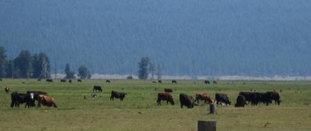
Ok...'bout them cows.....Hmmmm...now horses will stand side by side, head to tail to switch flys for each other....but cows...I did extensive research as I know, Michael, that you are only interested in the facts!! Here's what the experts had to say:Quote, originally posted by BHB » since cows are known for laying down when rain is approaching, i wonder if they dont also have some sense which tells them to face a certain direction into certain types of weather. ---Wind direction to keep bugs out of their eyes???? ---Lean into the wind, want to see/do what every one else it doing.---Facing the barn and grazing their way home?---Growing up on a cattle ranch I can assure there is nothing really to the direction they are standing. ---They could be grazing and working their way to the barns, or they too like to watch things and could be observing the cars that are passing. ---And for the record.... cows sleep laying down, so you can not tip a cow while they are sleeping AND OF COURSE A WEB SITE LINK:http://s-p-o-n-g-e.com/articles/article9.phpWhy do cows graze facing the same direction?By Historian Clineff "Why DO cows face the same direction while grazing." We began by studying the cows from behind as they graze. Trying to determine if perhaps they were staring at something close by. After being treated and released from the hospital, we discovered and published two very important observations.A grazing herd produces a large amount of Methane Gas. Never light a match behind a heard of grazing cows.We returned to the herd and remained careful to stay upwind. After four weeks of unsuccessfully trying to gain the cows trust, we had a break through. In her diary Ms. Goodall writes:"Success!!! I was finally able to infiltrate the herd and be accepted as one of their own. It was another disappointing day, I was making my way back to camp when I slipped and fell face first into a worm infested Pasture Patty. My stomach, associating the patty for the spaghetti I had earlier, began to expel the contents of said dinner. The cows in the area mistook my activity as my trying to "chew my cud" and seem to have accepted me as one of their own."This was the breakthrough we had been looking for. We were now able to mingle among the cows and observe their behavior closely. We were soon able to tell them apart and began naming them things like Bob, Jim, and Snookies. Our next big break came when we realized that, during the night, the cow we had named "Boy, he’s old, I wonder if he is going to die soon" was missing. We tagged the one we had named "He’ll be the next to go" and waited. The next morning he was gone. We turned on the tracker and, after a few days and a journey of over 500 miles, we followed it to a McDonalds. It was at this point we realized we were using the same tags the slaughterhouse used for choosing the next cow. With moral low, and the magazine pressuring us for results, we changed tags and attached one to the cow we named "No, that one over there." The next morning, the cow was gone. We turned on the tracker and began our final journey. After three days and two states, we were beginning to fear another visit to McDonalds, but then the tracker showed the cow had stopped moving. We turned down a dirt road and drove as far as we could. We had to go back to the last town we passed to get camping supplies, it looked like we were in for a long walk. After two days of climbing, we found ourselves deep in the uncharted mountain ranges of Kansas. After a hard day of hiking, we sat down to a meal of beef jerky and water, each lost in the despair of the seemingly hopeless quest upon which we had embarked. Fortunately for us this quest ended the next morning. We had just broken camp and had begun our trek westward. Jane slipped on a narrow ledge and, pulling me with her, we slide down the side of a steep hill and came to rest on the valley floor. We both stood, speechless at the sight before us. What we had taken for the whiteness of daisy petals was, in reality, the sun shining off the bleached bones of a billion dead cows. We had found it, the Graveyard of the Cows. And there, taking his last shuddering breath, was the cow we named "No, that one over there." Pulling out a map, we realized we had traveled in an exact straight line in the direction the grazing cows were looking. They were paying homage to the millions of cows who had gone on before them. After a night of feasting and passion, Jane and I began our return home secure in the knowledge we had finally solved that age-old question of the grazing cows. As you well know, Jane continued her career as a naturalist. My career was cut short when embarrassing photos came to light involving me and one of the cows. Dismissing my explanation of alcohol and mistaken identity, I was fired from How Now Cow and was unable to find work in the field ever again.
Friday, August 25, 2006
Thursday, August 24, 2006
What Do Bible Literalists Do?
What do they do when they are touring the Grand Canyon, or Glacier National Park, or the Gunnison Black Canyon, and they read the information board about the ancient geology of those places?
For background info, consider the Young Earth theory, in which an earth much younger than mainstream sciences thinks it to be had its antediluvian land masses shaped by Noah's flood. That is, the 80% of the earth's land that is currently covered by sedimentary layers had those deposits laid down in a short time, some say one year, and that all the major geological features were created during that time period.
The Young Earth theory, originally conceived, I believe, in the 1600's, modified and then mostly dropped in the 1800's, saw a partial resurgence of adherents in the early 1900's and then really began to catch on with Christian fundamentalists with the rise of that movement.
Or, do they even really wonder about it?
Wednesday, August 23, 2006
Groundhog Day
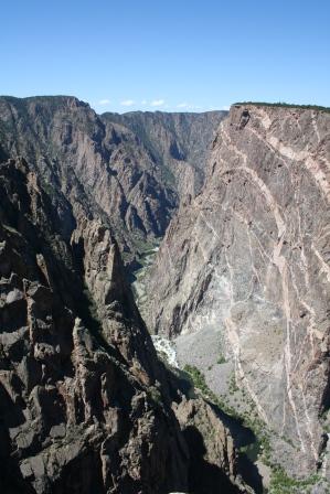
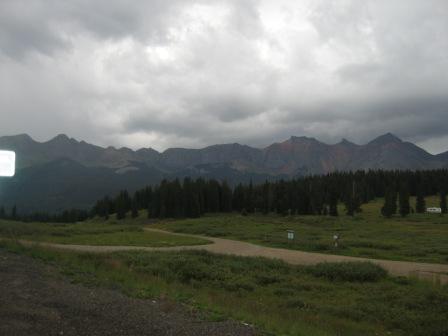
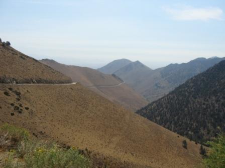
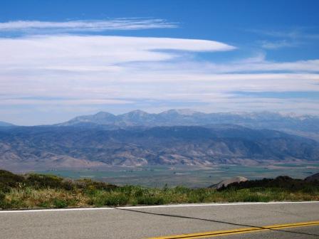
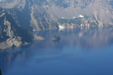
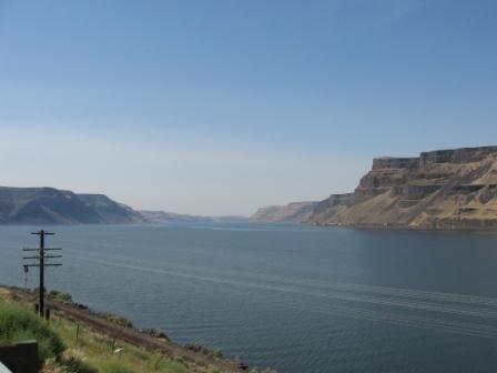
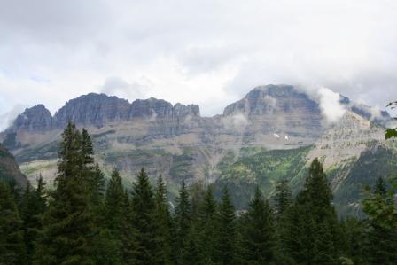
pic 1: Typical Black Canyon Scene
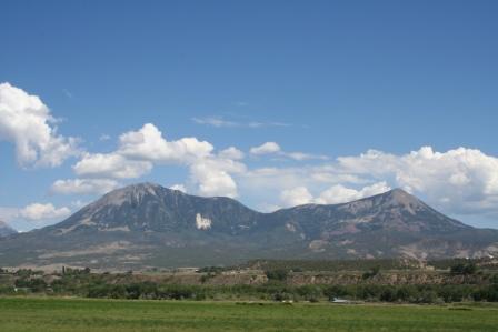
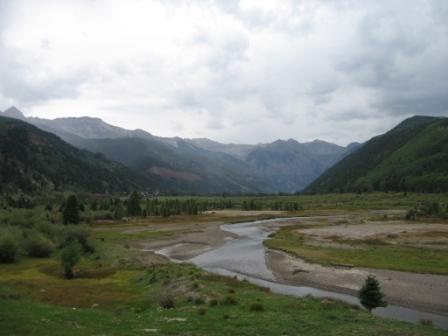
pic 2: High mountain meadows near Crawford...view of West Elk Mountains
pic 3: WHY ARE THE COWS FACING THE SAME DIRECTION?
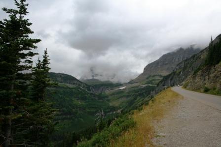
Day 22 August 23 Wednesday - 210 miles
Groundhog Day
I almost feel like Chevy Chase in his Groundhog Day movie. I wake up, go get the continental breakfast (coffee and cereal mainly), pack up, load up, gas up, hit the road. But in my case, the locales are always different.
Since the day’s ride schedule was not too long, in miles at least, I decided to wash clothes at a Laundromat. That done, I was on the road by a little after 10.
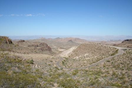
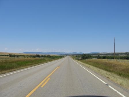
The first destination was the Gunnison Black Canyons. The canyon system is not too far out of Montrose and I had wanted to see it for years. The Black Canyons, so named because they are so steep and narrow that light can reach the bottom only when the sun is nearly directly overhead, were formed by the Gunnison River wearing through hard, crystalline, ancient rock; the Colorado River, by contrast, cuts through the much softer sandstone of the Grand Canyon.
In the 48 miles of the canyons, the Gunnison River drops more than does the Mississippi in its entire 1,500 mile length. (Test question: how much does the Mississippi drop? I mentioned this earlier.)
One road at the park runs straight down to the river at a grade of 16%, which is almost three times the steepest grade on interstates; I think the elevation drop is something like 2,000 ft. in less than 3 miles. We’re talking 1st and 2nd gear here, folks!
After being awed and then numbed by the vastness and wildness of the canyon, I ran back down to Hwy 50, continued east and over the Blue Mesa, and then turned north on Hwy 92, a scenic drive.
Hwy 92 was quite a surprise. First, I had no clue that it would be so twisty and slow. Second, I didn’t know it would climb so steeply. And third, it bent back on the map so that at one point it was maybe 10 miles, as a crow flies, away from where I was in the Black Canyon, but was over 40 miles away by road.
Hwy 92 at first ran up the side of a large mesa, crested it, and landed me in high mountain meadows. Once up on top, the road straightened out and I began to run at about 70. Then, I saw a small deer up ahead and let off the throttle to get a better look. BUT WHAT WAS I THINKING! That little sucker could run out in front of me. I grabbed the brakes, not an easy task because the road had been resurfaced and was coated with a fine, loose layer of small gravel. The deer, thank god, ran back into the woods. I was to see three or four more in the next five miles or so.
I turned west on 133 at Hotchkiss headed toward Carbondale, and this turned into a beautiful section. The road, smooth as it could be, continued to run across the high mesa before dropping a little into a very wide canyon where it passed through several coal mine areas where trains were being loaded for trips to utility companies.
Then, 133 climbed for a few miles and before descending along the Crystal River that ran into Carbondale.
So, north on 82 and I’m in Glenwood Springs. I did the usual, “Ma’m the internet in the room has to work,” and also visited with the other motorcycle riders who were camped out in front of their doors.
Supper, bath, read a little, download pictures, and do the journal. Just like Groundhog’s Day.
Tuesday, August 22, 2006
MY BUTT HURTS!
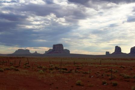
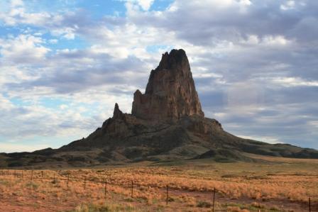
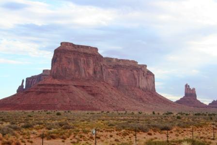
pic 1, 2, 3: buttes in Monument Valley
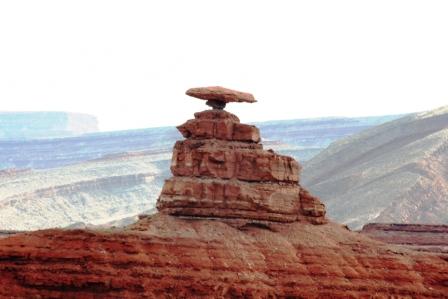
pic 4: Mexican Hat
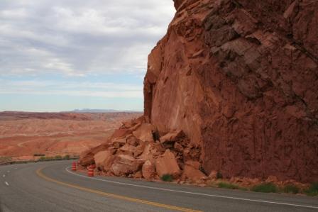
pic 5: rock calving near road...would have hated to be there when it happened
pic 6: small section of San Juan Mountains looking down on road
pic 7: Telluride is located up ahead in this canyon, up against the jutting sides of the San Juan Mountains.
Day 21 Tuesday August 22 - 310 miles.
MY BUTT IS SORE!
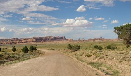
I got up early so as to see the eastern rising sun light up the buttes in Monument Valley. Alas, the sky was cloudy! And, it stayed that way all day wherever I went.
I drove north on Hwy 163 into Monument Valley. It was much more impressive than the pictures show. To really do justice, I’d have to get the light right and have a superwide lens. Here’s a good site for more pic. http://www.americansouthwest.net/utah/monument_valley/index.html
You might notice the thin red to black coating on some of the rocks. This is “desert varnish” owes its origin to microscopic organism that interact with the rock’s minerals and water, leaving the oxidized residue. Here’s a place for more info: http://www.nps.gov/cany/nature/geology/varnish.htm
(OH! While typing this I saw that there will be a new season of Nip/Tuck on FX TV. Great! What a dark show!)
I came upon a small, small town named Mexican Hat on the San Juan river and, of course, wondered where the name came from. Check out the pic and all is explained.
Before I reached Bluff, which is on a turn back to the east and south on Hwy 162, I climbed up a section that had “Road Damage” signs on the shoulder. Coming around a corner I saw why: some of the soft, sedimentary rock had “calved.” The picture shows a large chunk of rock that has sheared away from the cliff and fallen dangerously close to the roadway.
By the way, I had been playing leap frog with a car of Belgium tourists, them stopping for pic and then me doing the same. The whole eastern side of Utah, with its deserts, canyons, and mesas, is very popular to Europeans; they have forests, they have mountains, but they don’t have the red deserts and huge, eroded canyons and buttes that we do.
At Bluff, which is appropriately named, situated between the bluffs on both sides of the San Juan river, the land became dryer even the cottonwoods struggled, with many giving up the fight and their limbs and trunks becoming wasted visages of a better time.
162 ran into 160 that led to Cortez, and the road lay atop a mesa that was surrounded by the Colorado version of Monument Valley buttes, only these eroded pinnacles lacked the red color of those only 50 miles west.
At Cortez, inhabited by a large number of Native Americans, irrigation had been put to use and I once again was reminded that a little water can work miracles in dry soil.
From Cortez, I headed north on Hwy 145 that led to Telluride. I’ve always wanted to see Telluride, hearing that it was really isolated, situated at the end of a box canyon as it is.
Telluride was originally founded during the late 1800’s, as were many Colorado towns who owe their existence to mining, particularly gold and silver. And, like those towns, it almost died when silver prices were deregulated in 1893. And, like many town, it was saved by the selling of “white gold,” or, skiing.
It is nestled in a gargantuan box canyon formed by the San Juan Mountains. Unlike Aspen, Keystone, Vail, and, to a certain extent, Crested Butte, Telluride has “no way out” other than the way you came in. The town has, in the last few years, benefited from (or succumbed to…the same result is viewed differently) the real estate boom of ski-resort properties and tourism.
But to get there, I had to travel through rain coming over Lizard Pass, and I decided to have some coffee (God, it was the best ever) while waiting for the skies to clear.
After an hour, I put my rain gear back on and headed back out north on 145. The rain was not too terrible, but I had left my clear visor in LA for Logan to mail to me (I’m trying to lighten up for the final leg) and, even tucked behind the windshield, the rain drops stung like a million little bees.
I turned right on Hwy 62 and was greeted with the stupendous view of the Uncompahgre Peak to the right, heading up a platoon of fellow titans that looked down on the road.
The final run to Montrose was fast, about 80. I had been driving slowly because of the rain and the sharp turns and Harley begged to stretch his legs. We had left the San Juan Mountains and only the Uncompahgre Plateau guarded my left flank.
The motel is cheap, extremely clean, and run by the sweetest little old lady. And the internet is blazing fast. Yeah!
Tomorrow I’ll do the Black Canyons of Gunnison and head toward Carbondale, I think. I may go another way, but I want to take my time in the canyons, so Carbondale may be it. This will give me time tomorrow to work on investments and write some. And, I think I’ll read. Am currently reading a Harper’s story on the deplorable and unconscionable actions taken by the current administration with regard to the detaining and interrogation of suspected terrorists, some of whom are known by even the interrogators to pose no threat.
Low Point of the day: The clouds over Monument Valley
High Point of the day: Hanging out in the coffee shop in Telluride. It’s so nice to get back to CO where, everywhere you look, people are so fit.
Monday, August 21, 2006
Hwy 66 - Almost Didn't Get To Ride It...Or Anything Else!
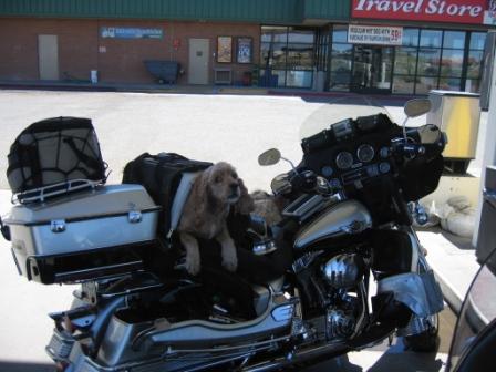

pic 1: who says you can't take the dog?
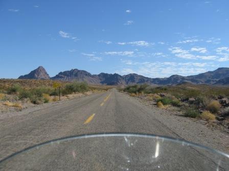
pic 2: hwy 66 as it runs into mountains
pic 3: wow! the timer on the camera works!
pic 4: twisty turn hwy 66 looking down on its curves.
pic 5: beginning of Monument Valley
pic 6: typical out of town, Native American living place...almost all residences have a mud "sweat lodge"...see the brown, dome-shaped structure.
Day 20 August 21 Monday - 385 miles
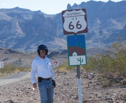
Historic Hwy 66 – I almost didn’t get to ride it.
I woke up and packed the Harley at 8 in the morning, and the parking lot was already beginning to feel like an oven. By 9, when I left, it was over 90 and within the next 30 min it hit 100. So, the leathers stayed on the back of the Harley.
Rt. 66 was running near I-40, and a quick look at the map showed there were a couple of good options for a ride on it, but I have to admit that I was surprised by the outcome.
We ran east for a little on 40, then turned north on 66 at Topock. Within a few miles I came into Golden Shores, which is little more than a few trailer houses, VFW lodge, and ratty convenience stores. At the VFW, a man starts to move across the parking lot toward the road I’m on. I slow a little, he looks RIGHT AT ME (the sun is in his back, highlighting me, mind you), and pulls out in front of me. I swerve to the other lane, thank god no cars were coming, jump on the horn, and miss him by quite a bit, but it could have been a very bad moment. What’s with that? He doesn’t see me! And I’m running three headlights! Jeez!
Hwy 66 is rough, no shoulder, but you can just sense the old cars moving up and down it, passengers leaning over buckets of ice to try and stay cool, cars overheating, and drivers praying they don’t break down. The thing is, if you wait for cool weather, the rain runs down the washes, potentially stranding motorists. If you go when hot, you face 100+ days. And then the road got really funky.
Up ahead, the looming craggy mountains loomed and the map showed that I would come up on Oatman. What the heck was Oatman I wondered? It is an old mining town that is still inhabited, almost completely as a tourist stop. The buildings are made from the vertical slats of wood, cedar I think, and corrugated metal. It was established in 1908 and over a million ounces of gold was mined. It eventually closed down, excepting for a few federal mines still nearby. I’m just amazed at how HARDY people were who lived in inhospitable places without a/c, McDonalds, or all the other conveniences we take for granted.
After Oatman, Hwy 66 went nuts…it would up, down, around, reminding me of the old PeeWee Herman show where the road sign turn warnings wound into a knot. In fact, Hwy 66, the whole time I was on it, impressed me with how its builders cooperated with the land rather than try to dominate it. Sadly, many drivers apparently did not do the same as the sharp, steep curves into the gulleys and washes were often marked with crosses.
But, I came down eventually and hit I-40. I wanted to ride another 70 miles of 66, but figured I would have plenty of good riding ahead on other roads. On this point, I think I was correct.
The road climbed into Flagstaff, eventually reaching 7400 ft and the temperature dropped accordingly, although it never got lower than 80. The road to Flagstaff was very much like you would see in Southern CO or some places in New Mexico. Cedars were plentiful and healthy, and there were more than a few signs warning of elk on the highway.
In Flagstaff I headed north on Hwy 89. Hwy 89 was interesting in that the landscape just totally opened up. For the last two days I had been riding desert hemmed in by mountains, but now the whole northern vista dropped away in a wide plain, with the mountains way out on the horizon.
Eventually, I ran along the west edge of the Painted Desert. Yes, it layered with red, white, and mauve.
From 89 I turned northeast on 160, figuring I would stay in either Tuba City or Kayenta, both of which were in the Navajo Indian Reservation.
Tuba City was not very impressive, to say the least, so I continued toward Kayenta…and I’m glad I did.
On the way to Kayenta, I began to run through eroded canyons and skirt weathered mini-mountains. It began to look like Utah, Moab in particular, in places. Little wonder, because I was approaching the border with Utah.
Kayenta is an Indian reservation town. Stray dogs, hungry, thin, some nursing mothers, roam everywhere. Some sections of the town are what you might call “typical reservation” while others are very new and clean. No alcohol can be sold or served anywhere on the reservation.
Tomorrow I’ll get up early to catch the morning light on the buttes.
Low point of the day: It being so hot so early.
High point of the day: 1st runner up is Hwy 66, but the real best note of the day was the phone call from my son, informing me how well his audition went for a small role on Veronica Mars. Later, he called me again and told me that he already had gotten the notice for a callback tomorrow. Whoo hoo!
Leaving LA...Out of the Frying Pan and into the Fire
1. Richard (daughter's boyfriend), Jes (daughter), Logan (son), Sarah (son's expecting wife).
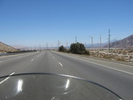
2. Only a small section of windmills.
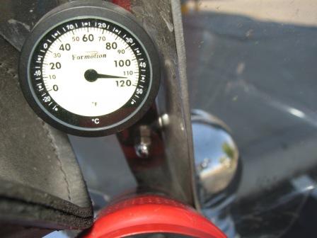
3. How hot can it get?
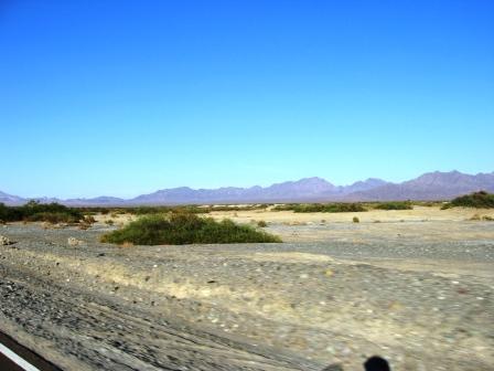
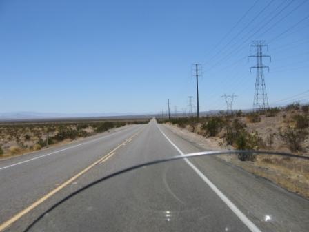
4. Typical scene for the day.
Dad Was Yelling At Me Today
August 20 Sunday - 300 Miles
If you had tuned in to the beginning of this trip, you read that my father is accompanying me. That is, some of his ashes are, placed in an Indian medicine bag and tied to the handlebars.
Well, I left LA at noon and, by a roundabout method, got on I-10 east. The temperature began climbing and now, at 9:30, it’s still in the 90’s. While we were on the road (check out the temperature gauge), Dad began to yell, “Holy Shit! I’ve already been in the oven once! What are we doing here?”
Well, there is no easy way to get out of LA and keep cool.
I drove east about 100 miles and had to stop. It was just so hot I couldn’t continue. I got some Gatorade, the first of several bottles for the day, took off my boots to use as a pillow, plugged my XMSR portable satellite radio’s earbuds in, and took a nap in the shade of the Valero gas station sidewalk. I woke up about 30-40 minutes later. Tiger had continued to kick butt in the golf tournament and I felt I could go a little further.
At most, I could manage 30-40 miles before having to pull over. In one place, the road sign read, “Turn of A/C to avoid overheating!” Yeah, right!
Apparently, in some times of the year, one area gets a lot of wind, judging from the windmill farms.
Every service stop along I-10 was strangled with cars, trucks, and passengers getting out for cold drinks and ice cream.
I was a little concerned about running the Harley in such heat, but after several others blew by me figured it would be ok.
Finally, I turned north on 177, just east of the Joshua Tree State Park. There, thank god, I gassed up. The attendant, cousin to the bad guys in Deliverance, took my $20 and tried to make change for a $10. He never batted an eye when I pointed out his error.
On 177, Harley and I plowed over waves of rolling desert, with some peaks and troughs so steep and abrupt that I could feel the negative and positive g-forces working on us.
I turned right on 62 and then left on 95 toward Needles. I had thought about taking I-10 to 95 and then go north, but it’s a good thing I didn’t because it was closed part of the way I would have taken I found out. Hell, I may have ended up in Phoenix!
All the way from east LA, the road ran thru desert, but once I turned north on 177, it became obvious that this was true Mojave Desert country. There was no shoulder on the road, and two cars that had pulled over or gone off were stuck.
I was heading north, with the setting sun on the left side of my face, but, thankfully, not for long, because it set behind the Old Mountains. As it did, it lit up the Whipple Mountains on my right.
Here and there were turnoffs leading to God-knows-where. I was having visions of mechanical trouble, wondering where and how I would pull off safely. But, knock on wood, all was fine.
As it grew darker, the heat only slightly loosened its grip…it was now 7 or 7:30 and it was still over 100.
About 30 miles out of Needles these really weird little trees, or big bushes began showing up. The plant looked as if a green, multi-tentacled octopus had been hurled from the sky and buried its head in the sand, with its thin, hairy limbs still streaming out behind.
About 20 miles from Needles I came upon the Sacramento Mountains. Now, don’t think of these as much more than well worn foothills, but winding up and through them was a great change of pace from the undulating desert waves that comprised the flatland of the desert.
The dry air is just killing my sinuses (or nasal passages or both) and I get all clogged up at night, which prevents me from getting really good rest. But, onwards and upwards. Tomorrow I’ll be riding historic Route 66 some.
It was great to visit with my babies in LA, but now I’ve charted course for home. By next Monday, I’ll be hard at work in my office-in-home, both getting it set up and continuing to work with my clients.
Low point of the day: Hitting 118 (temperature, not speed) on the road.
High point of the day: The final through-the-coming-darkness-badlands-canyon ride to Needles.
Saturday, August 19, 2006
Resting My Butt Till Sunday
Am taking a break off the Harley while in LA with my son and his wife. They are expecting a baby in Oct (this will be my 4th grandbaby!).
I will leave this madhouse Sunday afternoon and head east. Not sure yet if I will be going I-10 or I-20, but will eventually head up to the north east corner of Arizona where there are, supposedly, some scenic routes. I just hope they don't have the road construction that I encountered in CA.
I will leave this madhouse Sunday afternoon and head east. Not sure yet if I will be going I-10 or I-20, but will eventually head up to the north east corner of Arizona where there are, supposedly, some scenic routes. I just hope they don't have the road construction that I encountered in CA.
Thursday, August 17, 2006
Never, Ever, Never, Ever Again

top pic - sierra nevada to the west of hwy 395
next pic - road to nowhere in the Sierras]
last pic - road to LA and, eventually, Hell
Day 16 August 17 Thursday - 360 miles.
When does doing 85 put you in the slow lane? When in LA. That’s where I ended up, with my son and his expecting wife. To get here, though, takes some explaining.
I left Lone Pine at about 9 in the morn (all times are mountain time), and could tell that it was going to be a hot day. Still, I had on my leather chaps (they make me look so sexy) and my leather jacket.
The Sierras, including Mt. Whitney, one of the highest if not the highest, jutted up from the plains on the right. Unlike the Rockies, or even the Appalachians, where the rocky heights are introduced gradually by foothills, the Sierras thrust themselves upon you without any getting-to-know-you time.
I drove south, staying around 70, thinking about how the land had changed ever since coming down from 89. There, 395 just south of the 89-395 junction was lined with huge cottonwoods. Sadly, many of these majestic trees had white crosses affixed to their trunks. Here, scrawny junipers took their place.
I gassed up, then looked at the map and realized I had missed my turn to the west on J41, which I thought led me to Sequoia National Forest. So, I backtracked 8 miles and turned to the west.
I came upon skid marks in the road and two men with plastic bags who were walking the shoulders. Needing directions and information, I stopped and started up a conversation. The men told me that the REAL Sequoia forest was considerably to the west and north, but that the current road, though very rough and tricky, would give me some great sights.
After we talked for a little, I asked them what they were looking for and one said, pointing at the tire marks, “A friend of ours died here yesterday.”
I expressed my condolences, and asked, judging by the evidence, if their friend had run off to the right, overcorrected, and then flipped. He confirmed my suspicion, adding, “I think it was a cell phone death.”
Apparently, there was is no cell phone service where they all lived back up in the mountains and they usually checked their phone once they got to this particular section of the road. In his case, if this was the contributing if not causative factor, he must have been distracted with fatal results.
I decided to take the road up into the mountains. Over an hour and a half later I was back down at the wreck location. It was just going to be too long and too filled with unknowns to continue on that very rough and very tricky-to-drive road. But, it sure as Hell led up into the high valleys of the Sierra Mountains.
I continued to drive south on 395, leaving the High Sierra behind me. It heated up to 95 and the wind continued to blow in my face from the south. I set the cruise control on Rock and Roll. The road undulated and undulated and undulated…I was riding ocean swells, passing cars, trucks, and anything else that was slower than I was. Yeah, right, this was soon to change.
Then, 395 ran into the north side of San Bernandino and into I-15. I got on the interstate thinking that I was finally going to have an easier time of it. Wrong!
The closer I got to San Bernandino, the faster and tighter the traffic became. OK, now I’m going over 80 in a wind that did its best to intimidate me…and intimidate me it did. The interstate took a severe drop through a series of curves and I swear to God that I thought I was going to die. I hate the middle lane…no where to go if a problem occurs. If I take the right lane, then impatient drivers race into it in order to get around vehicles in the middle lane. The left lane is just hauling ass. I finally decided on the left lane…if I was gonna go out, I wanted to be sure to do it at full speed ahead.
I’m going 80 and 85 and spot a Harley rider up ahead. I tuck in behind him but can’t hold on…he speeds away. I then spy a trike (a three-wheeled Harley) and jump on his tail, regardless of what lane he wants, figuring that the two of us make a more formidable obstacle for the lane-changing, cell-phone-talking, cut-you-off-at-the-knees idiots driving Escalades and souped-up Hondas.
While the last 100 miles to I-15 were pretty bad, the last 70 into Fullerton were even worse; the worst was only horrible.
I never knew I could drive so long and so fast with my head between my legs, kissing my butt goodbye.
Highpoint of the day: morning coffee.
Lowpoint of the day: the last drive to LA.
Wednesday, August 16, 2006
My Love/Hate Affair With CA Hwy 89
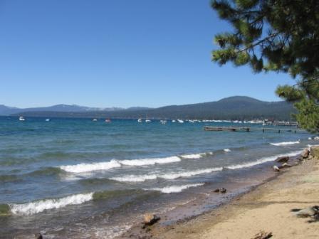
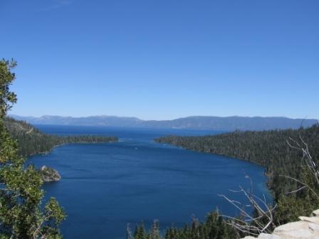
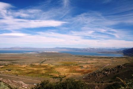
Pic, from top to bottom. Lake Tahoe, Emerald Bay at Lake Tahoe, Coming down Hwy 89, End of 89, Mono Lake
Day 15, August 16 Wednesday - 430 miles.
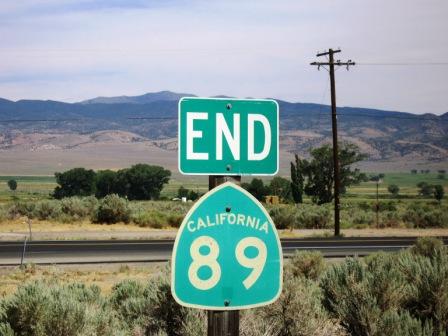
My love/hate affair with California scenic Hwy 89 ended when it ran into Hwy 395 below Carson City. How did it end? To tell the truth, the final miles decided the issue.
I woke late and took 395 down towards Reno and Tahoe. I turned west on Hwy 70 above Reno (I decided to bypass Reno in order to see more country) and then south on Hwy 49 which then hooked back up with 89 to run down the west side of Lake Tahoe.
What can I say about Lake Tahoe? Well, the first thing is that is truly is beautiful. The second is that I wouldn’t live there for a million years because it is horribly crowded. Just too many people and too many houses crammed into too small a place. And it was only a Wednesday!
Finally, south of Tahoe, the road opened up again, except that there was constant work and delays. Apparently, what they say about the mudslides in northern CA is true…the hills are always coming down on the roads and buildings; almost all of the work was crews cleaning the dirt and rocks off the roadway. And if you take the time to look at the hills (and I had plenty of time when stopped) you can see that they are nothing but loose, porous soil in which boulders are sprinkled much as are chocolate chips in c. chip ice cream.
I hated that road. But when it was clear, it was gorgeous. It was like a bad woman…hurting me and then making me fall in love with her all over again, only to mistreat me again. How would it end?
Still on 89, Harley and I rolled, and stopped way too often, through the 4 – 6000 foot passes, the land being mostly dry, almost semi-arid, but with hardy pines still the dominant tree. Then, we descended into a canyon, with the road running alongside some funny kind of sounding name stream. Up ahead I could see a mountain string that I figured we would ride over.
I started up the grade to the pass, and I started seeing some cyclists coming down. One rider was remarkable on his descent past me…the wind was gusting fiercely from side to side, the worst thing for a bike rider, but he was really moving out…much faster than even I would have gone down a mountain on my Trek.
The cottonwoods gave way to pine that eventually yielded space to stands of aspens. Then, after a turn or two, I was near the top of the pass, at almost 8,000 feet. This is only 2,000 ft higher than Tahoe, but I had lost altitude after leaving Tahoe, so the climb in total feet was pretty significant. And the view, what I could see through the smoke haze, was gorgeous. Even at that height, it was hot, 85, so I kept rolling. Once I hit the peak, and looked into the valley below, I knew how it would end with 89 and me…we would part on good terms.
The road down was a biker’s dream, pedal or motor. The roadbed was perfect, the turns predictable, the grade steep, and the views to die for. I passed a couple of teams of cyclists on their way up and knew they would be having a good day, albeit long.
Finally, 89 ended at 395. It was over. I forgave 89 for all the grief she had caused me; she left me with a lingering kiss and fond memory.
On 395, it was time to roll. The 65 speed limit was a joke. But there were two problems. The first was that, because it ran parallel with the mountain range, the wind whipping down the slopes clobbered me from the side much as was often the case on Hwy 93 in Colorado. But 93 didn’t run for long…now, I had over 100 miles to go. It was so windy that they even had wind socks along the road in places. The second problem was that there was, you got it, more construction.
At one, I was again, second in line to stop. The driver of the car in front had her window down and had a really good song playing. Finally, I couldn’t stand it, started up, rolled up alongside her, shut down the engine, and asked her who the band was. She said it was David and David…you had to order over the internet. Well, I’m gonna order it.
Soon, the flagger waved up around and she took the lead. After we passed through the other end of work, the last for the day, thank god, she stomped the pedal. She had told me while we were visiting that she was from Reno and going to LA. It was 350 miles and I guess she planned to get there in an hour or so.
Even though there was a fierce headwind coming up the valley from the south, I turned the throttle up and stayed back behind her…if there was a cop he’d nail her first.
But when she got stuck behind a truck, I was first around and took the lead for a while. For the next 75 miles we swapped turns up front. Then, when I was leading, I pulled into a gas station in Bridgeport and she followed me in. I got gas and she went in to buy cigarettes. When she came out, I had pulled the bike up to take a break. We started talking and it turns out she’s a surgical nurse in Reno going to see her cousin in LA. She had a ring with diamonds on her left ring finger, but when I said it was time to get going, she took a pen and piece of paper and wrote out her number and email. “If you’ve got time in LA, call or email me,” she said.
Oh, yeah, right! She’s a smoker, I’m not. I’m available, she’s not. I don’t need more trouble. But we had a nice chat.
From there, 395 had surprises for me. It climbed over several more passes, had no more work, and revealed some beautiful scenes. One was Mono Lake, near where the first placer gold mining operations took place. Another was the line of Sierra Nevada mountains that appeared on the right. Imagine driving up 75 in Boulder County, but all the land around you is flat, excepting that to your right is a steep wall of mountains, not the foothills that grow into the Rockies like by 75. And, to your left across the flatland is another wall of mountains.
The thing is, much of CA is valleys hemmed in by long lines of mountains. And these mountains and valleys vary in height from one to the other. For instance, Owens Valley, where I am now, is at about 4-5000 ft. I understand that the Sacramento Valley that eventually becomes the San Joaquin Valley are at a much lower altitude. But they, too, are walled in. The geography of CA is really interesting…when it holds still long enough for you to see and study it!!
I was running way late, fearing two problems. One was that I didn’t want to hit any animals. Hwy 89 was littered with the carcasses of dead deer, and they were big mothers. Now, on 395, I saw signs warning of ELK! The other problem was getting a room. All the travelers are like birds flying to roost at night. Wait too long and your spot in the tree or on the wire is much less than desirable.
In fact, I’m in Lone Pine, at the Dow Villa, an old historic, downtown motel. There are pictures of John Wayne everywhere. He (or more likely, one of the Old West characters he played) must have stayed here. There is NO BATHROOM in my room, only a sink. Just like the real west. I checked out the communal bath, saw the water on the floor and didn’t even bother to check inside the shower stall. The old “spit bath” thing is gonna work for me tonight.
Low point of the day: The traffic around Tahoe
High point of the day: The final miles of Hwy 89
Tuesday, August 15, 2006
Cool Hand Lucy

Day 14, August 15, Tuesday 410 Miles
Have you ever seen a road worker flagger, female, take a shower in front of the line of waiting cars? Read on.
I got a good start out of Bend, OR this morning. It was 60 and clear. My first destination was Crater National Park. I don’t know about the people who live there, but Hwy 97 sucks when it’s packed with traffic, which is most of the time. When not, it’s a decent road.
I turned west on the hwy below Beaver Marsh and ran quickly toward the park entrance. I love to ride when the sun is behind me. The only time I don’t is in town because I worry about cars not seeing me.
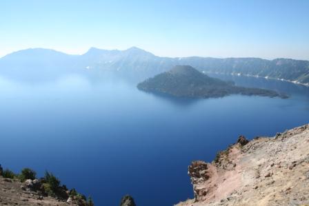
I turned back south on the road to the crater and then had a choice to go on the west or east side of the crater. I chose east in order to get the sun behind me while taking pictures. Alas, the haze from fires still hung in the air, but as the saying goes, “you take the pictures when you’re there…then buy the postcard if necessary.” They didn’t turn out too bad. The little spine-back looking rock formation is called the “Ghost Ship.” I’m not going to post all kinds of stuff about the lake cause you can Google it easily enough.
Leaving Crater Lake, I passed several fields of cows and, yes, they were all facing the same way in each field. You might recall a post I made early in the trip about this phenomenon. I’ve been puzzling about it the whole time. I thought I had the answer once: the cows all faced with the sun in their back. But, alas, this proved to not be true as cows in adjoining fields faced different directions. Oh, well.
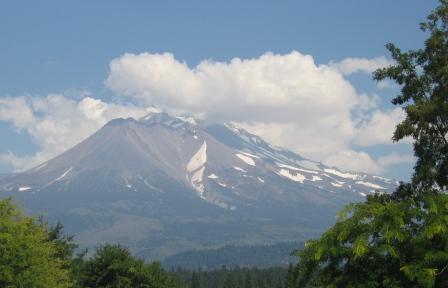
Then, back to Hwy 97 and head down toward Weed, CA. It was clear that I was in logging country, both from the log trucks on the road and the clear-cut sections on the mountainsides. The road up to this point was relatively smooth and fast, especially for a two-lane. In Weed, I took this picture of Mt. Shasta, the most southern volcano of the Cascade Range.
I decided to take Hwy 89 west off of I-5 just below Weed and head toward Susanville. The map showed the little dots on the road, designating it as a scenic drive. Well, this wasn’t the first time that the dots, instead of leading me to a scenic drive, lured me into a royal screwing. At first, the road was narrow, with no shoulders, and had large pines and firs only a few feet from the asphalt. I thought, wow, this road needs some work cause if you go off you’re dead. Well, my thoughts proved to be prophetic, because I began to encounter work sections after work sections.
At one, I was the second vehicle in line at the stop. After 15 min of waiting in the 90 deg. heat with leather jacket and chaps on, I pulled up on the right side of the car in front to chat. Two young guys were in it along with their dog. We visited while the woman flagger jawed with the guy on the radio…they were obviously doing the blue collar flirt thing. “Hey, hon, will you ever turn that ‘stop’ to ‘go’ for me?” And, ‘you getting all hot standing out there in the sun?” And on and on. Well, a water truck roared past us on the left and pulled up next to the woman. I wondered what that was all about, but looked down at my new friends in the car. The driver was looking at me, but the passenger was facing ahead and said, “Oh, my god, would you look at that!”
The driver and I both looked up and saw that the water/sprinkler truck driver had turned on a valve that released a shower of water about shoulder high in the back. The woman flagger had taken off her helmet, vest, and scrunchies and was half-crouched under the shower. She was wearing a, yes you got it, white t-shirt. She soaked her hair, then turned and let the water soak her chest. Then, yes I swear it's true, she turned toward the line of cars cooking in the heat and kind of sashayed about.
Then, she spent the next five minutes combing her long blonde hair out.
Now, don’t get me wrong, she wasn’t that pretty. I mean, she may have been ok for a the-bar-is-closing date, but that’s about it. Still, it was a picture. I just gawked and forgot to get my camera out of the case that I keep strapped to my belt for quick shots. Oh, well.
Finally, I was through the repairs and hit the section that had already been fixed. It was a biker’s heaven. I had two cars running a front door for me, a tailwind, and 5,000 ft of altitude. (It’s remarkable the difference riding a cycle at high altitudes makes. Down lower, the wind buffets a lot, even behind a shield, at fast speeds. Above 3-4,000 feet, the air is much thinner and you feel like you’re gliding through gossamer instead of swimming through pea soup.
On a smooth-as-glass road, the three of us ran at about 75-80 through heavily meadow calderas that morphed into forested lava fields and back again. I have one picture…notice the blur at the bottom.
Finally, down to Susanville. You may love northeast CA, but the towns there leave something to be desired in the way of art and theatre.
I'm so good at schlepping my stuff in and out of rooms now that it takes no time at all. By this time, my Harley and I have become well familiar with each other. I know every sound, every vibration, and every move.
Tomorrow it will be down through Reno and maybe include a jaunt by Lake Tahoe and I shall continue my peripatetic journal.
Summary: Low point of the day - Waiting on the construction work.
Highlight of the day – Riding those same roads where the construction work had been completed.
Monday, August 14, 2006
High Desert Harley
Day 13 August 14 Monday - 400 Miles
Yesterday I met a couple from Canada (ever since I go to Great Falls, MT it seems like 80% of the Harley riders were from Canada) who was touring with their Harleys and their 13 yr old daughter. The girl rode behind dad on his bike and mom had her own. They were doing about 4-5,000 miles. Most daughters that age don’t want to be on the same continent as their parents.
I checked email and investments; saw that the market would probably run up today and most stocks did not have much going on so I hit the road.
The first 100 miles to Walla Walla, Washington on Hwy 12 from Lewiston were great. At first, I ran alongside the Snake River. Then, it pulled away and continued to run down through a small canyon. The road was a biker’s dream. If I had had a sports bike, I would have let it rip at over 100 in places. The turns were constant radius instead of the often treacherous decreasing-radius type I sometimes encountered in Colorado. For those of you who don’t do turns, a decreasing-radius turn is one that tightens on you as you go into it. So, I could set the lean angle and just go.
At Walla Walla, the road became very congested until I hit hwy 730 that led to I-84. Sadly, I had to pass Kennewick, home of the Kennewick Man. The Kennewick Man is a skeleton that was discovered there and has since become the source of a great deal of controversy. Native Americas, under the N.A.G.P.R.A. (Native American Graves Protection and Repatriation Act), have a right to remains and skeletons and other funerary cultural objects that are discovered or in museums. Thing is, some anthropologists believe that the Kennewick Man is non-Native American, even though he dates back thousands of years. According to some people, he predates Native Americans. Here is a link: http://www.kennewick-man.com/
I got on I-84 as it clung to the edge of the Columbia River, and just hauled butt. It was 90 degrees by now, and the cool morning ride along the Snake River was only a melted memory.
Finally, I got to Hwy 97 and turned south. Oh, great, now I climbed out of the river valley and up onto the High Desert. I swear I thought I passed the skeletons of some Harley riders, still astride their rusted bike, their fat little bodies now only bleached bones. It was a l-o-n-g 140 miles to Bend, Oregon. There was no wind, which was good unless I had a tailwind. The windsocks on the pitiful excuses for airports (small strips) were as limp as Richard Nixon's protestation that he was "not a crook".
On the last stretch, I could have had a great view of a volcano to the west, but NO, the smoke from a forest fire somewhere north and west had thrown up a grayish-red pall that obscured the view in all directions.
Hey, what’s with the Oregon law about pumping gas? I stopped to fill up and this yo-yo comes out and stands by the pump…in between me and the pump handle. He keeps looking at me and saying “Hi.” After the third, “Hi,” I say, “Can I help you or something?”
He says, “Yeah, I gotta pump your gas.” You know me with my hard of hearing ears right? So what do you think I heard him say?
Well, anyway, we work that out and he said, “I’ll just swipe your card and hand you the pump, you can do the rest.”
OK, it’s a bad joke but it’s true. And I asked me why it was the law and he says, “Oh, for safety. Or for jobs. I’m not sure.”
So I pump my own damn gas, and what does he do? He leans against the wall and lights up a smoke. Gimme a break for crying out loud.
I get into to Bend in time to run by the Harley shop and get a full fluid oil change. You know what HD stands for don’t you? Hundreds of dollars. So Harley Dav idson did to me what the attendant didn't!
Whatever.
I’m in, clean, fed, tired, and going to bed. Tomorrow I continue south on hwy 97 and do the Crater Lake tour. Time for the good camera.
Sunday, August 13, 2006
I've Had My Wheaties Today For Sure


Day 12, Sunday, August 13 – 365 Miles
Well, I’ve seen all the wheat fields I ever want to see. But more on this later.
I left Kalispell, home of cowboys and cowgirls, by 10:30. It was a late start because I took time to wash clothes.
I drove west on Hwy 2 into the setting moon with the perfect riding temperature of 60. Soon, I was wending my way along the valley between gentle-shouldered mountains. Somewhat like CO, but very green. It reminded me of a combination of Crested Butte and Steamboat Springs, but with smaller mountains.
If you ever want to fish, northwest Montana is the place to go; I must have passed a thousand lakes and rivers.
The day was much different from the previous, where the Going-To-The-Sun road ended up being a Going-Into-The-Cold-Rain journey.
I passed Logan’s creek, Logan’s Cabins, Logan’s this and that. (In Glacier, there was a Logan Pass.) I tried to find the reason why so many places were named “Logan” but couldn’t.
I hit the most northern point of my trip, just north of Bonner’s Ferry, which is only about 20 miles from Canada. Then, south on Hwy 95.
I passed thru Sandpoint, home to a beautiful lake that is much prized for its fishing and which offers the opportunity for skiing, boating, para-sailing, sailing. It was probably one of the prettiest lakes I’ve ever seen.
I crossed I-90 (man, it’s a long way above I-10) and headed down toward Lewiston, my intended destination. Soon, with the temp now 95, I got held up for 30 min because of construction. Sitting on the damn bike in that heat is a real pain.
But, afterwards, I was curving through the wheat fields of northern Idaho. Let me tell you, Kansas or any other place that grows wheat has nothing on this place. Note the pictures. Almost every inch of land was cultivated, even up the sides of the steeply rolling hills; it reminded me of the pictures of China, where the land is scarce.
At one point, I realized that Idaho had it backwards; they had “crop squares” instead of “crop circles.” See the pic.
Eventually, I topped a rise and saw Lewiston below me, situated between the Snake and Clearwater Rivers. Lewis and Clark had made a stop here in 1805. Eventually, it became a port for steamboats. The Nez Perce Indians lived there, enjoying the “banana climate” that is the result of warm air funneling through the lower river valleys. (Only a fifty miles north, a Honda rider I met complained about the -10 winters.)
Got a great hotel, had dinner, met some bike riders, got some advice and am now planning the rest of my trip.
I have changed my plans and will not to go to Seattle. There just isn’t enough time. Instead, I’ll run west on 12, parallel the Columbia River for a while, then head south on 97. 97 will take me through Bend, Oregon, by Crater Lake, and along the Cascades.
Taking this route will eventually lead me to 395 that will take me pretty much straight to LA. I’ll do the Redwood Forest and the Pacific Coast ride another time…maybe when (if, ha!) I ever have another girlfriend.
So, I should be back to Shreveport, via Boulder, CO by August 25-26-27.
By the way, Lewiston is in the Pacific Time Zone and is farther west than LA. How about that!
Glacier National Park Pictures

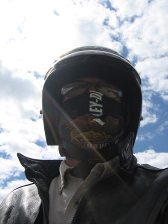
View these in reverse order! Me bundled up, approach to Glacier, and pic in Glacier.
Saturday, August 12, 2006
If You're Going To Hell, Go Thru Glacier Natl Park First


Day 11 August 12 Saturday – 265 miles
(will try to get pic up when Blogger will let me)
Because if you do, your eternity in damnation will be bearable. But I’m getting ahead of myself.
I ran the Harley into the Big Sky Harley shop in Great Falls to see if they could fit me in for a quick check on fluid and to make other minor adjustments. They were able to accommodate me (all was fine) and I was on the road a little after 10.
I went north on I-15 and then west on Hwy 44. 44 took me to Hwy 89 that ran into Glacier National Park. The temp was about 70 when I started and kept dropping as I went north and west. Since the elevation was higher in Grand Falls, the sky was closer. At one point, the road ran up through a cut in a ridgeline, and the section up the hill was shiny and glimmered from the mirage effect. The sky was blue and partly cloudy. So, the road, as it disappeared into the mirage and up into the cut, looked as though it was heading straight into the clouds! I felt my wheels would grow wings and I would just continue going up after the road dropped. Sorry, but I couldn’t get that picture.
The land is what is called "high desert." Again, hay is the major crop.
I passed into the Blackfeet Indian reservation and while the Indians were relegated to junk land in many instances, the Blackfeet must have had connections or just been lucky because it was good land for cattle and horses. And the horses were everywhere. I saw them running along ridge tops and flowing in a brown-black-white stream down into the lower areas. Makes me want to get a horse!
After a quick lunch at St. Mary’s (I missed the fantastic dessert), it was up and into the clouds for real.
The temperature kept dropping and I kept putting clothes on. Then, near the top, I hit the rain. It was 45 degrees, windy, and rainy. So, this part of paradise was less than ideal.
It was something like 60 miles through Glacier National Park. The road was nervously narrow, but scenic pull outs were everywhere. Sadly, there was much more I wanted to stop and see but, again, time is a factor.
The rain cleared up, thank god, and I would have loved to have been able to spend more time, maybe even camp some. But I’ve got a long way to go. I figure that I’ve covered about half of the miles I’ll do on this trip, but I will have shorter mileage days coming up as I go to the scenic two-lane routes in the Pacific Northwest.
Speaking of which, as I came down the west side of Glacier National Park, I was on the west side of the Continental Divide, the rainy side, the large-ferns-under-trees side. So far, this is absolutely the prettiest country I’ve seen. I’m back in the mountains, but they are not as dry as those in Colorado and are completely covered by pines. While the altitude here is lower, the height difference between lower areas and mountains is still measured in thousands of feet.
I tried to find a hotel in Whitefish, MT, but they were having a Huckleberry Festival and all rooms were taken. So, down the road to Kalispell I went. Hello, Super-8. And not too soon because about 30 min. after I checked in the Harleys started thundering in, looking for a place to bed down.
Now, all the bikes are lined up in front of the office (the desk attendant said to park them out front so they could be watched) and if anybody wants to make a haul, they’re all gathered in one place.
Tomorrow is Sunday and I have a long way to go…much of the drive will be on gorgeous two-lane roads through the mountains and along side lakes and rivers. And this is just the start of the Pacific Northwest.
Not Enough Time
Am having my Sat. morn coffee, looking at a map, and figuring distances on my laptop. I've come about 2800 miles, not quite halfway. Next Wed will be two weeks. Now that I'm approaching the Northwest, I want to take more scenic routes (is there any road that isn't scenic?) and get off the interstate. But this will take mucho time. Which means that I will have to cut back on time somewhere else. Where? I haven't done any camping yet because it's been hot and the really pretty country awaits me. But how will I do these four things:
1. See the backcountry areas
2. See Seattle
3. See Logan and Sarah and Jes and Richard,
4. Camp
Of course, one of the factors is that I am working on this trip, with the need to be able to review investments and talk to clients, and I'm not going to slight that work.
And, you can only do so many miles a day on a motorcycle. Plus, if you wait too long to get a room, they're all sold out. I doube that will be a problem in the less-traveled areas, and even if it does I can always pitch a tent somewhere.
Even in these smaller towns, Glendive, Fargo, Great Falls, I can see the Chinese restaurants and dark-skinned smaller motel owners (Pakistanis?). I have to believe that these business owners stay pretty much to themselves because I never see them on the streets, in the restaurants, on in the bars. Of course, it might would require a coincidence to meet up with them because their numbers are so small. Still, you have to imagine that don't easily, or necessarily even want to, mix in with the locals. Which leads me to wonder about their children...what do they do for school and such?
Well, I need to try to get the bike in for an adjustment. Let's see if the shop can make it happen.
Then, have to hit the road...bikers are already heading out.
Friday, August 11, 2006
The Land of Big Sky, Roadkill, and Meth
Day 10 August 11 Friday 360 miles
I left Glendive and headed northwest on Hwy 200. The weather was a pleasant 80 and, lo and behold, I had a slight tailwind again. Wow! (Unfortunately, this would soon change!)
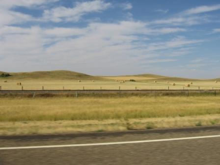
The land began its rise and fall, almost in a regular rhythm, quickening at times and slowing at others. Hay crops filled my view, in a 360 degree circle, all the way to the horizon. The hay looked to be golden ambrosia for horses. For me, it was soon to almost too much. God, where does all that stuff go?
The wind changed direction and began to pound me from a 2 o’clock position. Eventually, I had to stop and put on the leather jacket just to reduce the billowing of my shirt.
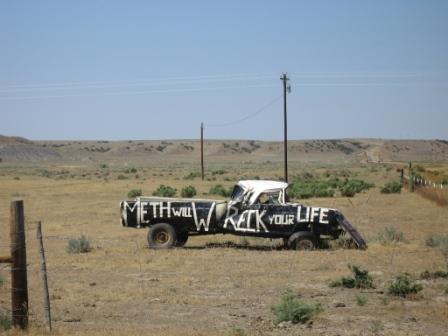
Signs exhorting the evils of meth were present in every small town and on roadsides. One sign said:
Life is a gift
Give it your best
Stay away from meth
Check out the pic.
As the asphalt passed under my wheels, I kept noticing all the blood and gut splatters. There was roadkill everywhere: skunks, rabbits, birds, deer, and even a few liberals. I have been avoiding nighttime riding on the highway for just this reason; what a way to screw up a bike or me, as far away from home as I am now!
The further west I got, the dryer it became. Soon, I was running under virgas, something I hadn’t seen since leaving Colorado. I was hoping that the rain that was evaporating before it hit the ground would somehow make it all the way down and cool me off some.
The rolling hayfields eventually yielded to miniature badlands, and I ran into miles of smoke that had blown down from grassfires somewhere north. It wasn’t enough to totally obscure the road, but I did have to pay more attention in the winding, up and down curves.
I punched through the blue haze and found myself again under Montanan’s clear, blue, big sky., and the land again changed to fields of gold warming under the August sun. But, god, the wind just kept pounding and pounding on me. I pulled over in a nowhere-land town no bigger than two or three large city blocks to grab a snack and the trees that had been planted for wind breaks just howled. My whining as I got back on the Harley was totally drowned out.
Eventually, I rode through Ponderosa country. I kept expecting to see Ben, Hoss, Little Joe, and Adam, up on the hillside on their winged stallions. Instead, I did see some horseback riders galloping along. In the distance, I could see the, I think, Julien mountains that I would soon be approaching.
I made it into Great Falls, MT and was welcomed by a car wreck that took place just after I turned out of an intersection. I was lucky I wasn’t 50 to 100 ft further back! Nobody was hurt, but they all got out and started pointing fingers at each other.
Now, I’m holed up in a cheapo motel, riding off the next door bagel shop’s internet! Will get cleaned up, go for dinner, and check out the town. Want to find a bar and sit and watch TV, have a drink, talk to the locals. Shouldn’t be too hard.
Subscribe to:
Comments (Atom)

